Open source visualization tools enable realtime site monitoring.
The data is out there and there’s more of it every second. With every trip around the sun, our world throws off data, much of it is geospatial data and images from satellites, cars, and mobile devices. Some of it is incidental, some of it is intentional like mapping, measuring, watching, etc. Cesium was founded in 2011 to better use all that data. The company provides a software platform for 3D geospatial data. Cesium grew out of the aerospace industry when a team from AGI (Analytical Graphics Incorporated) spun off to develop a streaming content engine for geospatial data. Cesium CEO Patrick Cozzi said they saw a trend for streaming graphics in 2011 driven by the widespread commoditization of powerful GPUs combined with “fast enough” JavaScript and the arrival of Khronos’ WebGL for browser-based streaming graphics. The AGI team also saw an unprecedented proliferation of geolocation data and they knew just what they wanted to do with it. They wanted to build a platform for SaaS applications to make geospatial data visual and available. One of the linchpin developments for the company came in 2015 with the development of 3D Tiles, an open specification allowing heterogeneous geospatial data to be stored in layered sets with a hierarchical layer of detail. 3D Tiles allow huge amounts of data to be streamed, zoomed in on, details turned on and off, all interactively. Cesium built 3D Tiles using glTF, Khronos’ asset format for WebGL. 3D Tiles have also been accepted by the Open Geospatial Consortium (OGC) as a Community Standard. OGC is collaborating with Khronos to maintain and extend the standard.
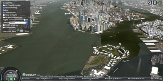
The collaboration means 3D Tiles is widely accepted by companies in the geospatial industry. Support for glTF and WebGL means that applications using 3D Tiles can be accessed in all browsers. Also, the reliance on accepted standards means that developers have access to a wealth of open source resources. For instance, have a look at this presentation of New York City that includes over a billion OpenStreetMap buildings in New York City. Cesium built this app to demonstrate 3D Tiles.
Through its work in aerospace and defense, Cesium has several high profile customers including AGI, of course, and also Lockheed Martin, Raytheon, and Rafael. It also has customers building autonomous vehicle applications and drones, and in the construction industry. Trimble uses Cesium for visualization tools for the massive amounts of data gathered by Trimble’s metrology tools. Trimble’s Clarity tool enables everyone involved in a project to “see” progress as it’s reported by multiple sensor sources.
Cesium has also teamed with Komatsu to build applications for the construction industry. Komatsu is best known for building big machines for mining, construction, warehouses and industry, and forestry; as we know, these machines are getting smarter and more autonomous.
Komatsu has announced plans to develop Smart Construction products, which will rely on the 3D vision and accuracy Cesium can provide.
Cesium built the Komatsu Smart Construction Dashboard, which enables users to monitor a construction site from anywhere in the world, see how it changes over time, and compare architectural plans with what’s going on, on the ground.
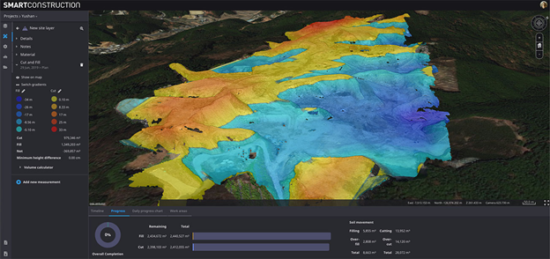
This enables customers to create a digital twin of a project with accurate and measurable data such as distances and volume. It can calculate cut and fill, slope, contours, and more. The system can compare the progress of a project as captured by various sensors including data coming from machines, drones, onsite photography, etc., with the original 3D CAD model of the project and update estimated completion data. And, Cozzi tells us it can report on the size of stockpiles on site. Normally, he says a worker may climb on top of stockpiles and use a GNSS rover or similar capture device to build a 3D model and calculate how much is available. Using data from all the sensors around and above the site enables models to be constantly updated in a much safer process.
What do we think?
Worldwide digitalization. Technology is on a steady path to digitize absolutely everything. It’s changing the world in obvious ways including making surveillance states more efficient and dangerous, but also making streets safer and enabling rescues. And, in the case of construction, it’s making people’s jobs safer and projects more efficient.
As we wrote in an earlier article, Cozzi is very committed to open source technologies as a way to speed development and deployment. He heads the glTF Working Group for Khronos and he has opened up the work his own company is doing. 3D Tiles is one example.
Probably, hopefully, the only way to make the world better is to keep it open and make information freely available even if the tools to do so can also be used to clamp down control, and spy on people. Now, when we’re increasingly having to stay home and monitor the world via our computers, is a very good time to be talking about the opportunities, challenges, and responsibilities of open information sources.