Leveraging the power of electromagnetic remote sensing for water, environmental, and infrastructure resilience.
Bentley Systems’ new Aarhus GeoSoftware pushes the envelope in operational groundwater management, spearheading the move for sustainability projects involving exploration, contaminants, and infrastructure resilience. The powerful new software packages include AGS Workbench, SPIA, Res2DInv, and Res3Dinv. Combined, these innovations raise the bar for the processing, inversion, and visualization of geophysical data—from ground-based and airborne electromagnetic (EM) studies, electrical resistivity tomography (ERT) remote sensing, and other sources.
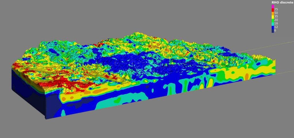
Quickly identify subsurface materials via 2D and 3D images
AGS software lets users create 2D and 3D images of subsurface electrical resistivity. Software outputs are used to distinguish and differentiate subsurface materials, which are subsequently modeled in Seequent’s Leapfrog Works to aid in various subsurface investigations.
The innovative software employs electric field measurements, collected at ground level or with airborne sensors, to map the subsurface distribution of water, mineral deposits, and clays. Electrical resistivity provides a more comprehensive overview of how water, mineral deposits, and clays are distributed. When the water contains other compounds such as salt, researchers and industry professionals can infer the distribution.
Seemingly endless applications
The genesis of AGS software was to ensure clean drinking water for future generations by mapping groundwater across Denmark. It is now used in many different areas:
- Locating subsurface faults and cavities to mitigate construction risk
- Investigating ore bodies, waste rock, and tailing processes in mining
- Monitoring movements of groundwater and contaminants to help understand environmental impacts of modelling dam and tunnel stability
- Assessing landslide risk to gauge asset resilience or construction plan impacts
Ongoing research push advances to the next level
Seequent will continue to collaborate with universities and research organizations worldwide through ongoing engagement with Aarhus University for the development of AGS geophysical solutions.
Graham Grant, chief executive officer of Seequent, said, “The acquisition will add new geophysical data processing capabilities to our workflows to help advance subsurface investigation and modelling. AGS software, coupled with Seequent’s advanced geologic modeling and analysis software, creates a key tool in helping understand and manage groundwater and assessing risk in infrastructures such as dams and canals. We’re excited about the new possibilities this opens up for our collective users worldwide, improving lifetime digital twins.”
Toke Højbjerg Søltoft, chief executive officer of Aarhus GeoSoftware, said, “Seequent’s global reach will allow AGS software to positively impact more projects worldwide. As we continue to develop solutions, our users will benefit from our tools being in Seequent’s ecosystem and workflow. We’re excited to join Seequent and to work together on our shared vision of helping organizations make more informed and sustainable decisions through a better understanding of the subsurface.”
Seamlessly integrating workflow steps
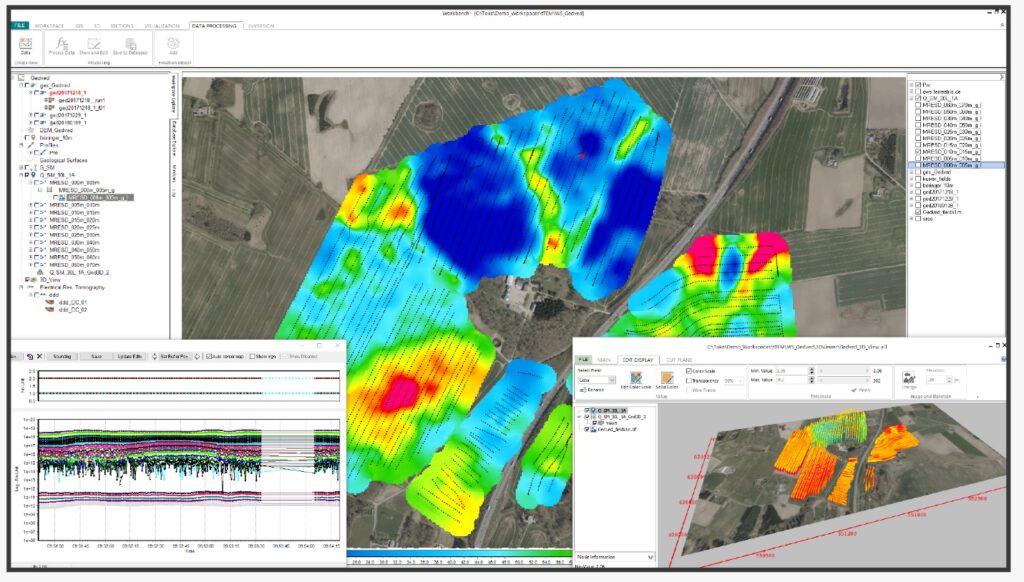
The AGS Workbench package is based on a GIS interface and includes dedicated data processing modules for various geophysical data types. The package integrates all workflow steps from processing the raw data to final visualization and interpretation of inversion models.
Remote sensing via EM induction
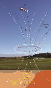
Airborne Electromagnetic (AEM) remote sensing uses electromagnetic induction to collect extensive volumes of data from an aircraft. This fast, cost-effective method of subsurface mapping can cover large areas (10s–1000s of km2) in a few days. It requires no new drilling or ground access, and, using 3D modeling and visualization software, provides a quick turnaround for mapping the subsurface.
Creating a detailed 3D overview of subsurface resources
The technique involves a helicopter or a small airplane towing a sensor loop approximately 100 feet (30 meters) above the ground. This generates an electromagnetic signal transmitted into the earth based on the subsurface properties. At this point, a secondary field is created and measured at the aircraft. These data are then processed to estimate subsurface electrical properties. Depending on resistivity or conductivity, the returned signal helps geoscientists establish the nature of the subsurface. Sensing data is processed and inverted in AGS Workbench software. It is then combined in Seequent’s Leapfrog Works to create a 3D model that gives a detailed overview of resources.