Bentley is leveraging Imagery Insights from the Google Maps Platform to rapidly detect and analyze roadway conditions. As a result, Bentley is offering new asset analytics capabilities in its Blyncsy product, which uses AI on crowdsourced imagery to detect infrastructure and roadway issues.
Google offers a lot of things to a lot of people and companies. Consider Google Maps, for instance, which has provided accurate directions for many people over the years, not to mention snapshots of locations around the world. Bentley Systems, which calls itself the infrastructure engineering company, is using that platform’s data to go beyond locating a friend’s address or determining optimal driving directions and routes to a locale many miles away
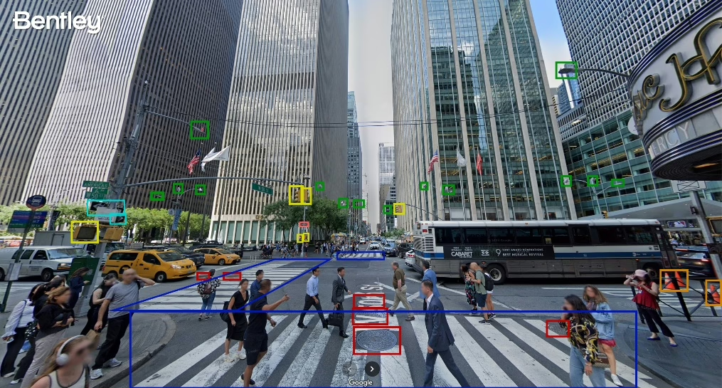
Google Street View imagery to detect roadway issues and assets, from potholes
and crosswalk paint condition to street signs and traffic lights. (Source: Bentley Systems)
Unveiled at Google Cloud Next 2025 this week, Bentley announced new asset analytics capabilities that take advantage of Imagery Insights from the Google Maps Platforms to detect and analyze roadway conditions. These new capabilities are available in Bentley’s Blyncsy, part of Bentley’s Asset Analytics product portfolio, which applies AI to crowdsourced imagery for automated roadway asset detection and inspection that will help infrastructure professionals improve roadway maintenance.
Bentley contends that the unique Imagery Insights combination of Google Street View, Vertex AI, and Blyncsy will enable departments of transportation, and the engineering firms and consultants supporting them, to better identify areas of concern and analyze changes in the condition of roadway and transportation assets over time. The addition of Google Street View’s global panoramic imagery allows Bentley to provide highly detailed analysis of assets along with visual references, while Google’s Vertex AI adds the ability to build and maintain models to alert transportation agencies of changes to infrastructure assets before they become safety hazards.
In addition to supporting roadway maintenance activities, these capabilities can also aid in disaster recovery efforts, providing a cost-effective solution for conducting rapid damage assessments, which can help affected communities rebuild faster.
This is not the first relationship forged between Bentley and Google. Last fall, the companies entered a partnership to integrate Google’s high-quality geospatial content with Bentley’s infrastructure engineering software to improve the way infrastructure is designed, built, and operated. According to Bentley, the expansion of its relationship with Google will enable the company to further develop its growing infrastructure asset analytics capabilities—initially in the transportation sector, with other industries to follow, it said.
LIKE WHAT YOU’RE READING? INTRODUCE US TO YOUR FRIENDS AND COLLEAGUES.